


15.4.1 Coverage by protected areas of important sites for mountain biodiversity
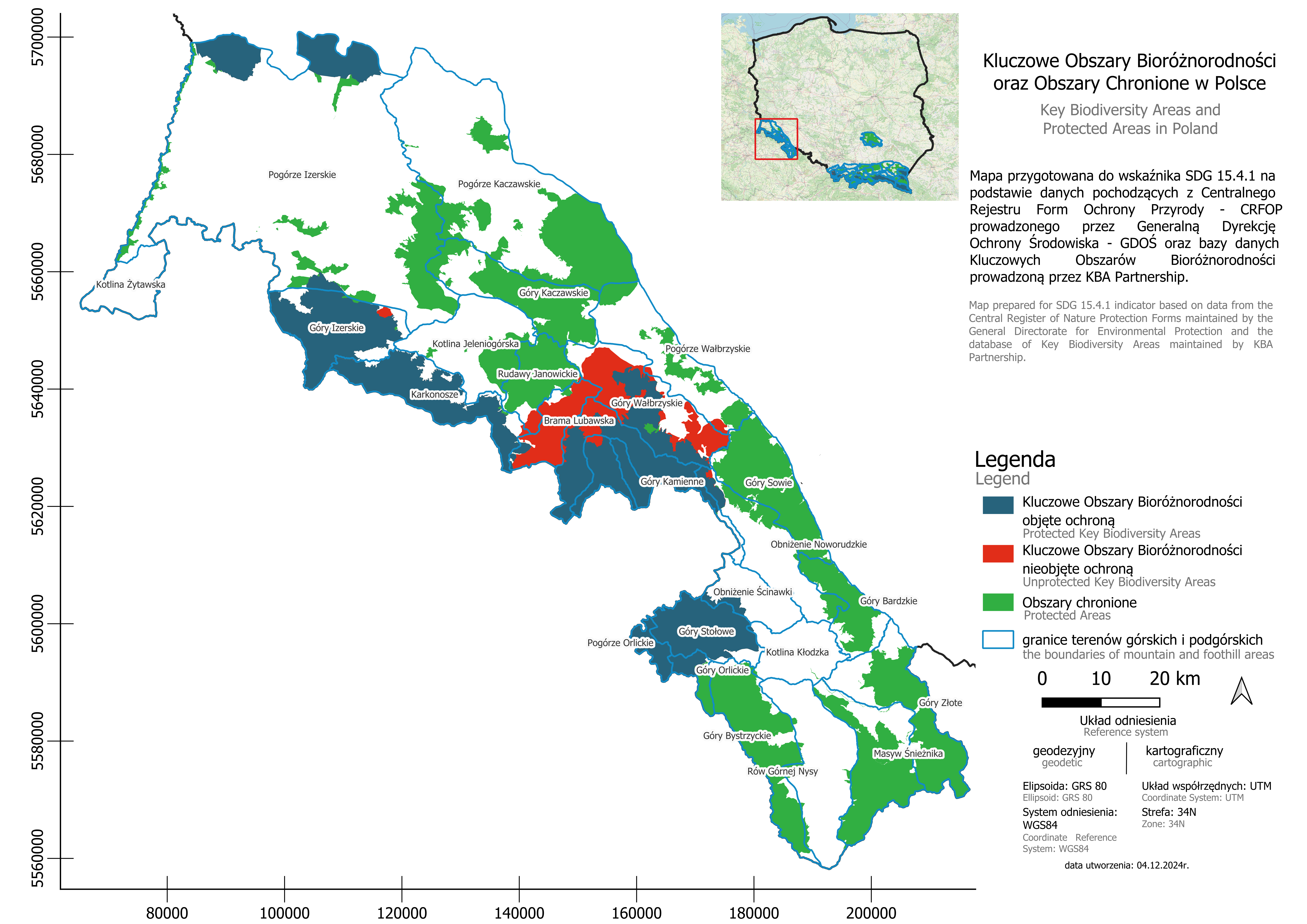
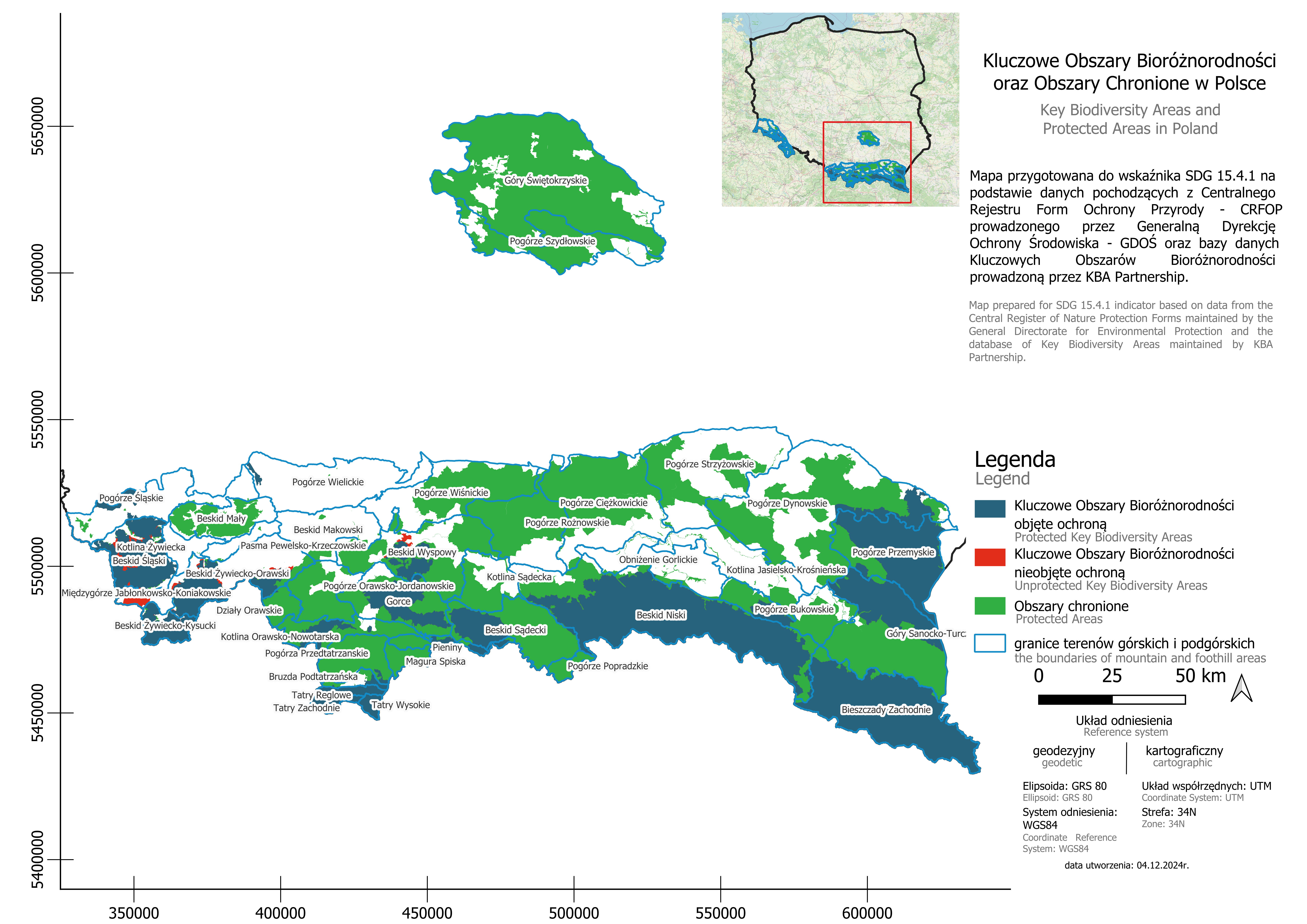
| 15.4.1 Percentage of protected areas important for biodiversity in mountain areas in Poland (%) | 95.4 |
Data refer to 2024.
Interpretation
The indicator shows the proportion of Key Biodiversity Areas (KBA) in mountain regions that are under protection.
The higher value of the indicator, the more effective the protection of biodiversity in mountain areas (which supports the preservation of natural resources and unique species).
Here you can find a set of context indicators, the data for which come from official statistics of Statistics Poland. The purpose of context indicators is to complement the results of experimental SDG statistics, deepen information on the monitored phenomena and provide support in assessing progress in implementing sustainable development.
How did we calculate the indicator?
In order to calculate the indicator, the following stages were carried out:

1. The areas selected for the calculation of the index were mountain regions marked as mountain ranges, including mountain massifs, foothills, uplands, and basins.
2. Administrative geospatial data from the General Directorate for Environmental Protection (the Central Register of Nature Protection Forms) regarding protected areas in Poland were used, such as national parks, landscape parks, reserves, protected landscape areas, Natura 2000 areas ("habitat" and "bird" sites), and RAMSAR areas.
3. Information on Key Biodiversity Areas (KBA) in Poland was obtained from the Key Biodiversity Areas (KBA) Database.
4. The geospatial data were analyzed using QGIS and ArcGIS software to determine the components of the index.
5. Based on the overlap of protected areas and biodiversity areas in mountain regions, the indicator 15.4.1 was calculated.
Detailed information on calculations based on the UN methodology can be found in the indicator metadata.
What sources were used to calculate the indicator?
The indicator was calculated based on the methodology proposed by the UN using data from sources:

The Central Register of Nature Protection Forms - a database maintained by the General Directorate for Environmental Protection, which contains detailed information about areas and objects under legal protection in Poland. It serves as the primary tool for collecting and sharing data on nature protection forms, with the goal of supporting conservation efforts and providing access to public information. The register includes various forms of nature protection, in accordance with the Nature Conservation Act.

The Key Biodiversity Areas (KBA) Database - a global database managed by the KBA Partnership that collects detailed information on Key Biodiversity Areas (KBA) worldwide. It contains data on the location, size, and criteria used to designate an area as a KBA. The data from this database are publicly available and are used for both research purposes and the development of environmental policies, as well as for analyzing the impact of development projects on nature.

The OpenStreetMap database is an open, global collection of geospatial data, encompassing detailed information about infrastructure and the environment worldwide. This project collects spatial data, including detailed information about infrastructure elements, administrative divisions, and the natural environment. The data is gathered, updated, and verified by a global community of users and volunteers, ensuring its currency and a high level of detail.
Validation
Being prepared...

What is the meaning of the indicator for sustainable development?
The creation of protected areas is an effective tool in the protection, restoration and long-term management of mountain ecosystems. These areas play a key role in securing ecosystem functions, such as water retention, climate regulation and soil protection. Protecting important biodiversity areas in mountain ecosystems is essential to halting the loss of biodiversity and promoting the sustainable use of natural resources. It also contributes to supporting local communities and the development of the regional economy.

Applications for local government units
Indicator data provide information that can support local government units, among others, in more effective and conscious management of natural resources (including mountain areas). This in turn enables the protection of nature while taking into account the needs of the social and economic development of a given region. They can also be useful, among others, in creating policies that protect local resources, which in turn increases the potential of regions in areas such as tourism or science and education. Protected areas become a place for conducting educational programs and research projects.